Please find the link for my Google Earth GIS presentation here:
https://drive.google.com/file/d/0B9GCo7StOMHNZlBWa1UzWHdUYzg/view?usp=sharing
Monday, November 7, 2016
Wednesday, October 12, 2016
BRYAN-COLLEGE STATION, TX: Economic Base & Urban Growth Analysis
In recent years, growth in College Station has caused it to emerge as one of Texas' many strong secondary/tertiary growth markets. Despite its relatively small size, short distances to major population centers (DFW - 2.5 hours; Houston - 1.5 hours; Austin - 2 hours; San Antonio - 2.5 hours), and the presence of the major university around which the MSA is centered are likely contributing drivers to the growth of Bryan-College Station. This post will analyze recent employment changes resulting from this growth and then discuss changes to the physical fabric of the area.
The 2015 population of Brazos County (215,037) represented a 10.4% increase over the 2010 population, outpacing the overall Texas population growth rate of 9.2%. Employment in the Bryan-College Station MSA, a slightly larger area than Brazos County, was 101,040 for 2015 and 92,990 in 2012, representing an 8.66% increase over the 3 year period.
BASIC INDUSTRIES
Industries in College Station having a Location Quotient above 1.0 are included in the basic industries table below:
College Station's basic industries of Architecture & Engineering; Life, Physical & Social Science; Education; Food Preparation; Office & Administrative Support; and Construction & Extraction have a cumulative Basic Employment of 14,095.
Total Employment is 101,040, which yields an Economic Base Multiplier of 7.17.

Oddly, given Texas A&M University's constant expansion, both the Architecture & Engineering and the Education sectors saw slight losses between 2012 and 2015. Thus, the 8.66% overall job growth of College Station between 2012 and 2015 was largely driven by the Science, Food, Office and Construction sectors. From this point, I will focus only on these 4 growing Basic Employment sectors to describe employment growth in College Station.

Using an estimated 5.52% rate of growth of national Employment over the same period, the National Share of the growth rates are estimated for each. The National Growth Share of these growing basic industries' 2012-2015 growth was 1,734 jobs, or 22.15% of growth.

The Industry Mix effect compares the national growth of each individual category to the overall US employment growth over the same time period. This effect is responsible for a gain of only 30 jobs, a mere .38% of growth.

The Regional Shift table separates the local growth within an industry from US growth of that industry to account for regional differences in the growth of an industry. This accounted for 6,066 jobs, or 77.47% of the growth.

For a more concise analysis of the actual growth, the table above combines the three Shift-Share factors to find the growth of each category, leading to a total growth of 7,830 jobs in these 4 growing Basic Employment sectors.
With the National Share and Industry Mix factors contributing a very small amount to the total growth, the Regional share is most responsible for actual growth in the Bryan/College Station submarket -- over 3/4 of it.
In the next section, I'll discuss how this employment and population growth has affected, and will continue to affect, the Bryan-College Station area.
GROWTH PATTERNS


The above map shows the Future Land Use Plan for College Station, the southern half of the BCS "Microplex". Examination will reveal something particularly rare for a city: College Station has no true CBD. The only true "walkable" area in College Station consists of the University's main campus and the currently-urbanizing Northgate District to the north. This makes sense, as the largest concentration of employment and certainly the greatest concentration of people at one location is the University itself.
However, College Station seems to take the Multiple Nuclei Model and apply it on a smaller scale across this one jurisdiction alone. The FLUP calls for urbanized and mixed use nodes (Brown) at a variety of locations, including the existing Northgate and Eastgate areas, as well as the Post Oak Mall area (likely a redevelopment area within the next 2 decades), the mostly-multifamily area to the south of the university, and the mixed-use Tower Point district to the south. The interstitial space between these nodes consists, generally, of Suburban, Restricted and Unrestricted; Neighborhood Conservation Areas, and General Commercial (Particularly along the Texas Ave and University Dr corridors. The little remaining space is given over to a smattering of other uses including Medical and Business Parks. This widespread nature and distribution of employment is quite unique among cities, and likely college towns in particular.
Future development in College Station will be two pronged. In the first prong, new development will continue to the south of College Station, eventually extending well beyond the existing city limits and pushing toward Navasota to the south. However, the development barriers to the east and west prevent extensive development in these directions, and the commute from Navasota will be cumbersome to some. Additionally, the University has numerous plans for expansion over the next several decades, ensuring it remains a vital driver of the local economy. These pressures lead to the second prong: redevelopment of existing areas. Much of College Station developed recently. This sleepy college town wasn't truly awakened until close to the end of the 20th century. But these intense development pressures will lead the older existing areas to be redeveloped more quickly than they might be in other cities with more room to grow in multiple directions. Already, the Northgate area is seeing its second and third high-rise student apartment buildings begin construction just beyond the University's shadow. These new buildings replace former banks, low rise apartments, blighted retail areas. While some questions as to their financial feasibility remain, they will be pieces of the ever-expanding BCS urban fabric for years to come, and mark the beginnings of what few thought the area would ever have: a skyline.
sources:
http://www.bls.gov/oes/current/oes_17780.htm
http://www.bls.gov/oes/tables.htm
https://www.census.gov/quickfacts/table/PST045215/48041,48
http://cstx.gov/Index.aspx?page=2920
The 2015 population of Brazos County (215,037) represented a 10.4% increase over the 2010 population, outpacing the overall Texas population growth rate of 9.2%. Employment in the Bryan-College Station MSA, a slightly larger area than Brazos County, was 101,040 for 2015 and 92,990 in 2012, representing an 8.66% increase over the 3 year period.
BASIC INDUSTRIES
Industries in College Station having a Location Quotient above 1.0 are included in the basic industries table below:
 |
| Data collected from Bureau of Labor Statistics |
College Station's basic industries of Architecture & Engineering; Life, Physical & Social Science; Education; Food Preparation; Office & Administrative Support; and Construction & Extraction have a cumulative Basic Employment of 14,095.
Total Employment is 101,040, which yields an Economic Base Multiplier of 7.17.
Oddly, given Texas A&M University's constant expansion, both the Architecture & Engineering and the Education sectors saw slight losses between 2012 and 2015. Thus, the 8.66% overall job growth of College Station between 2012 and 2015 was largely driven by the Science, Food, Office and Construction sectors. From this point, I will focus only on these 4 growing Basic Employment sectors to describe employment growth in College Station.
Using an estimated 5.52% rate of growth of national Employment over the same period, the National Share of the growth rates are estimated for each. The National Growth Share of these growing basic industries' 2012-2015 growth was 1,734 jobs, or 22.15% of growth.
The Industry Mix effect compares the national growth of each individual category to the overall US employment growth over the same time period. This effect is responsible for a gain of only 30 jobs, a mere .38% of growth.
The Regional Shift table separates the local growth within an industry from US growth of that industry to account for regional differences in the growth of an industry. This accounted for 6,066 jobs, or 77.47% of the growth.
For a more concise analysis of the actual growth, the table above combines the three Shift-Share factors to find the growth of each category, leading to a total growth of 7,830 jobs in these 4 growing Basic Employment sectors.
With the National Share and Industry Mix factors contributing a very small amount to the total growth, the Regional share is most responsible for actual growth in the Bryan/College Station submarket -- over 3/4 of it.
In the next section, I'll discuss how this employment and population growth has affected, and will continue to affect, the Bryan-College Station area.
GROWTH PATTERNS
As is the case in most contemporary metropolitan areas, Bryan-College Station represents a Multiple Nuclei model for urban growth. The close proximity of Bryan and College station caused them to grow into one urban mass over time as each spread out from its center.
The Brazos river to the southwest and the Navasota river to the northeast are densely forested and surrounded by wetlands and low lying areas, with few crossings. These serve as natural barriers to development, hence the area's elongated NW-SE orientation.
Additionally, the primary Transportation Corridor through the area, SH 6 - a grade-separated freeway throughout Bryan-College Station - also runs NW-SE between these two rivers. It provides easy access to several major population centers and thus bears some resemblance to the Axial Model for development.
The above map shows the Future Land Use Plan for College Station, the southern half of the BCS "Microplex". Examination will reveal something particularly rare for a city: College Station has no true CBD. The only true "walkable" area in College Station consists of the University's main campus and the currently-urbanizing Northgate District to the north. This makes sense, as the largest concentration of employment and certainly the greatest concentration of people at one location is the University itself.
However, College Station seems to take the Multiple Nuclei Model and apply it on a smaller scale across this one jurisdiction alone. The FLUP calls for urbanized and mixed use nodes (Brown) at a variety of locations, including the existing Northgate and Eastgate areas, as well as the Post Oak Mall area (likely a redevelopment area within the next 2 decades), the mostly-multifamily area to the south of the university, and the mixed-use Tower Point district to the south. The interstitial space between these nodes consists, generally, of Suburban, Restricted and Unrestricted; Neighborhood Conservation Areas, and General Commercial (Particularly along the Texas Ave and University Dr corridors. The little remaining space is given over to a smattering of other uses including Medical and Business Parks. This widespread nature and distribution of employment is quite unique among cities, and likely college towns in particular.
Future development in College Station will be two pronged. In the first prong, new development will continue to the south of College Station, eventually extending well beyond the existing city limits and pushing toward Navasota to the south. However, the development barriers to the east and west prevent extensive development in these directions, and the commute from Navasota will be cumbersome to some. Additionally, the University has numerous plans for expansion over the next several decades, ensuring it remains a vital driver of the local economy. These pressures lead to the second prong: redevelopment of existing areas. Much of College Station developed recently. This sleepy college town wasn't truly awakened until close to the end of the 20th century. But these intense development pressures will lead the older existing areas to be redeveloped more quickly than they might be in other cities with more room to grow in multiple directions. Already, the Northgate area is seeing its second and third high-rise student apartment buildings begin construction just beyond the University's shadow. These new buildings replace former banks, low rise apartments, blighted retail areas. While some questions as to their financial feasibility remain, they will be pieces of the ever-expanding BCS urban fabric for years to come, and mark the beginnings of what few thought the area would ever have: a skyline.
sources:
http://www.bls.gov/oes/current/oes_17780.htm
http://www.bls.gov/oes/tables.htm
https://www.census.gov/quickfacts/table/PST045215/48041,48
http://cstx.gov/Index.aspx?page=2920
Sunday, May 1, 2016
URBAN DEVELOPMENT PATTERNS: Bellaire, TX
In this post, I will discuss the patterns of urban growth and development in my hometown of Bellaire, TX.
 Bellaire is unique to the Houston area primarily for one reason: as an independent city, Bellaire maintains its own very strict zoning ordinances and building regulations. Replats and zoning changes of any kind are extremely difficult to obtain from a constantly development-wary city government. For this reason, developers, builders, speculators and homeowners are chained to the single-family format originally planned over a century ago.
This policy has allowed the neighborhood character to remain relatively intact even as nearby areas become increasingly more densely built and heavily populated with commercial retail, townhomes, apartments and condominiums.
The First Boom: WWII Expansion
 Bellaire was founded by William Wright Baldwin in 1908 after he purchased the 7,449 acre Rice Ranch, and was one of Houston's original "streetcar suburbs", originally serviced by a streetcar running from Houston, down Holcombe and Bellaire Blvd. to the town center, until it was abandoned in 1927.
 Development in Bellaire was relatively slow, and it remained a sleepy, residential and agricultural town on the outskirts of Houston until the post-WWII building boom made it an attractive place for returning veterans to establish their families.
It is for this reason that most of the original housing stock is made up of humble, one-story ranch homes often on plots of land as small as 5000 square feet (50x100), built between (approximately) 1940 and 1965. The buildout more or less concluded Bellaire's first building boom, and development zoomed further west and south.
The Second Boom: Built By Oil
Facing decline following the 1970s, which proved a tough decade for the Houston area, the location - only a few miles from downtown and in the shadow of the Med Center and Galleria area employment hubs - and Bellaire's well-regarded schools, kept the area somewhat attractive. Development was once again reignited by the oil boom of the 80s as more and more residents were priced out of the "it" areas of the time - River Oaks, et. al. - and ventured outward to greener (and more moderately priced) pastures.
The area was well regarded for its schools, safety, and community atmosphere, but the "Not Quite River Oaks Money" crowd would not be satisfied by the humble nature of the existing housing stock. Instead, they began to tear down these existing homes - some of them barely 20 years old - and replace them with newer, much larger homes, but still constrained to the tight original lot sizes.
 To preserve open space, protect trees, and ensure proper storm runoff, the city mandated that all new single-family new construction must be either 2 or 3 stories tall. The resulting housing stock from this second era of building (Ranging from the oil boom 80s until the 2006 financial crisis) consists mainly of either acutely banal (right) or excessively ornate (bottom) "McMansions" (often suspiciously identical to the bloated tract homes of suburban Houston) crowded onto a 5-7,000 square foot lot.
The second boom replaced approximately half of the original houses in Bellaire, and new constructions powered forward at a breakneck pace until the 2006 financial crisis.
Though the building isn't quite as rapid as I remember it from my younger years, the decade since the
second boom cooled off has been good to Bellaire economically. Land values were high before the recession - around $300,000 for the average mid-block lot in 2006. Since Houston's strong recovery, the prices have gone astronomical: those same lots today fetch almost double the price tag.
Meanwhile, my old block continues to be built out (re-built out may be more accurate), as do many others. As the years go on, that "bingo" moment of spotting three houses in a row, each of distinctly different eras and styles, has become more and more prevalent.

This policy has allowed the neighborhood character to remain relatively intact even as nearby areas become increasingly more densely built and heavily populated with commercial retail, townhomes, apartments and condominiums.
The First Boom: WWII Expansion
 Bellaire was founded by William Wright Baldwin in 1908 after he purchased the 7,449 acre Rice Ranch, and was one of Houston's original "streetcar suburbs", originally serviced by a streetcar running from Houston, down Holcombe and Bellaire Blvd. to the town center, until it was abandoned in 1927.
 Development in Bellaire was relatively slow, and it remained a sleepy, residential and agricultural town on the outskirts of Houston until the post-WWII building boom made it an attractive place for returning veterans to establish their families.
It is for this reason that most of the original housing stock is made up of humble, one-story ranch homes often on plots of land as small as 5000 square feet (50x100), built between (approximately) 1940 and 1965. The buildout more or less concluded Bellaire's first building boom, and development zoomed further west and south.
The Second Boom: Built By Oil
Facing decline following the 1970s, which proved a tough decade for the Houston area, the location - only a few miles from downtown and in the shadow of the Med Center and Galleria area employment hubs - and Bellaire's well-regarded schools, kept the area somewhat attractive. Development was once again reignited by the oil boom of the 80s as more and more residents were priced out of the "it" areas of the time - River Oaks, et. al. - and ventured outward to greener (and more moderately priced) pastures.
 |
 To preserve open space, protect trees, and ensure proper storm runoff, the city mandated that all new single-family new construction must be either 2 or 3 stories tall. The resulting housing stock from this second era of building (Ranging from the oil boom 80s until the 2006 financial crisis) consists mainly of either acutely banal (right) or excessively ornate (bottom) "McMansions" (often suspiciously identical to the bloated tract homes of suburban Houston) crowded onto a 5-7,000 square foot lot.
The second boom replaced approximately half of the original houses in Bellaire, and new constructions powered forward at a breakneck pace until the 2006 financial crisis.
Post-Recession Bellaire and where we go from here
Growing up in Bellaire, it was amazing to me to see the various historical eras represented around me by houses. Perhaps less jarring to most than to someone with a keen interest in architecture, development and building like myself, I was always struck by this dichotomy.
 |
| The familiar "old. new. old. new. old." rhythm of a Bellaire block |
My parents built their house just as the second boom started to fade. At that time, we were only the second redeveloped property on our block. The houses on either side were built in the mid 1960s, as was the compact red brick home that used to occupy the lot. I can still see that block with all of the original houses on it in my mind, but it's changed significantly even since I left for college in 2010.
 |
| Everything's bigger in Texas |
second boom cooled off has been good to Bellaire economically. Land values were high before the recession - around $300,000 for the average mid-block lot in 2006. Since Houston's strong recovery, the prices have gone astronomical: those same lots today fetch almost double the price tag.
Meanwhile, my old block continues to be built out (re-built out may be more accurate), as do many others. As the years go on, that "bingo" moment of spotting three houses in a row, each of distinctly different eras and styles, has become more and more prevalent.
 |
| Bellaire Bingo |
I cannot say that I totally approve of the development patterns in my hometown, nor will I be surprised when the astronomical and always-increasing land values in Bellaire lead dollar-chasing developers and builders to begin demolishing the two story houses of the second boom. But what I can say is that these unique development patterns have created some of the most incredible lot-by-lot housing diversity I've ever seen.
FAVORITE DEVELOPMENT: Mueller, Austin
The 711 acre site was previously occupied by Robert Mueller Municipal Airport, which was operational as Austin’s main commercial airport from 1930 to 1999, after which it was replaced by the bigger and better Bergstrom International Airport several miles to the north.

For several years, the prime, centrally located real estate sat unused, until city council approved a development plan for a unique mixed-use, new-urbanist community that follows the “Highest and Best Use” principle to a T.

The innovative master plan aims to accommodate 13,000 residents as well as 13,000 employees, with 4 million square feet of commercial space and 5,700 homes centered around 140 acres of open, public space.


A variety of home types are available, ranging from affordable to upscale, including apartments, condominiums, row houses, garden homes and more traditional, rear-loaded single-family. There seems to be a focus on creating a modern aesthetic throughout the project; commercial and public buildings are of a distinctly contemporary feel as are many of the homes, interspersed with homes of more classic and traditional architectural styles along the way.


Community and walkability are heavily emphasized within the project. Bike lanes and pedestrian paths are at least equals to automobiles, a far cry from the typical automobile-friendly Texas development. A variety of sustainable measures were undertaken to ensure the project remains environmentally friendly, including a 1:4 ratio of trees to parking spaces in car parking areas to reduce the heat island effect and extensive recycling efforts during the deconstruction of the existing airport facility, among many others.

Development site: http://www.muelleraustin.com/
Developer site: http://www.catellus.com/
All photos from development site.
REAL ESTATE FAILURE: Highland Towers Collapse
The Highland Towers complex was located in the city of Ulu Klang in Malaysia. The development consisted of 3 high-rise residential towers constructed between 1974 and 1982. It was originally constructed at the base of a steep hill, which was terraced with a series of retaining walls in the late 1980s. An existing creek on site was diverted through a culvert.

In 1991, a new housing complex was constructed on the hill behind the project. Additional water runoff was diverted through the on-site culvert, exceeding its designed capacity and thus increasing the water content in the soils around the site. By 1992, water could be seen seeping over the retaining walls, suggesting a high level of saturation.

The two weeks preceding the collapse saw constant rainfall, further saturating the soils. At 1:35 PM on December 11, a landslide severely damaged the retaining walls and also piled up saturated soil on the base of Tower 1’s foundation. The instability of the soil and additional pressure caused the foundation to snap. Block 1 of the Highland Towers development, now completely separated from its foundation, toppled over and completely collapsed. In the end, 48 were dead and many more were injured. Blocks 2 and 3 were permanently evacuated.
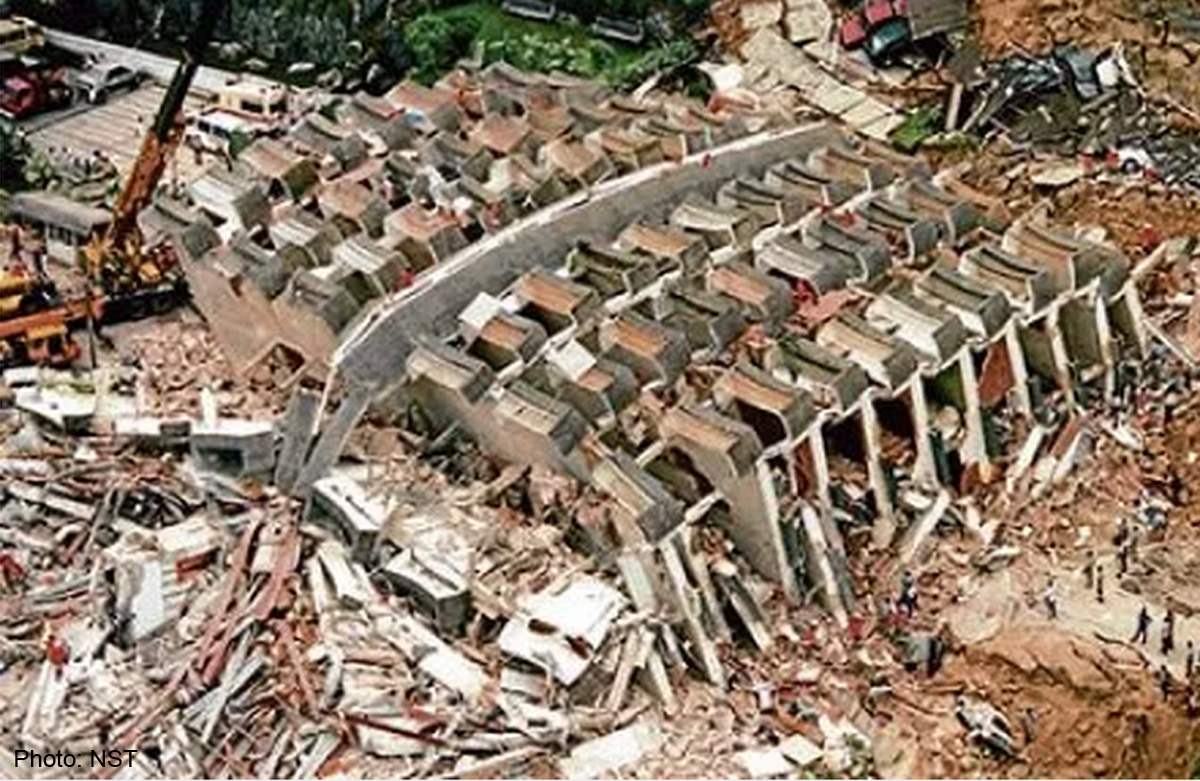
The investigation revealed 5 primary causes for the collapse:
1. The drainage of the adjacent development
2. Two weeks of continuous rainfall saturated the soil
3. Pools of water created unstable, swamp-like conditions at the base of Block 1
4. Piles supporting the building were not supported laterally
5. An underground limestone cave beneath the development collapsed, creating soil instability
An extensive lawsuit led to a RM 52 Million ($15.4 Mil USD) settlement; the engineer and architects’ names were withheld from the public. Some special considerations that may have prevented this tragedy. Retaining walls should be able to resist overturning even with the additional pressure generated by a landslide or any similar event. Additionally, the climate and erosion were not taken into effect. Additional planning for areas receiving so much rainfall, and the possible erosion accompanying it, has the potential to save lives.
Photo links:
http://photos.wikimapia.org/p/00/01/67/40/85_big.jpg
https://terrifictop10.files.wordpress.com/2014/01/highland-towers.jpg
https://buildingfailures.files.wordpress.com/2014/02/shanghaicondo_02.jpg
Monday, February 1, 2016
Introductory Post

In a sense, I've always been interested in development. I've wanted to "build buildings" for as long as I can remember. As a child, I was fascinated with buildings, from houses to skyscrapers. I initially decided, at a very young age, to pursue a career in architecture and stuck with that decisions for quite some time. I began my undergraduate experience studying at Northeastern University in Boston, a big change for a born-and-raised Texan. It was an incredible life experience that I will certainly never forget.
I eventually began to realize, for a variety of reasons, that I had chosen the wrong school, wrong city, and wrong college environment entirely, leading to my decision to transfer to Texas A&M. The more I studied architecture, and began to work in the industry, the more I realized that while I was fascinated with architecture and design, I saw my career taking a slightly different trajectory.
The emergence of sustainable technologies and mixed-use development strategies has made the development industry a very interesting place to be. This is what ultimately led to my decision to pursue a graduate degree in land development. Following my graduation from this program, I hope to eventually own and operate a company focusing on sustainable mixed-use development. I believe this program will provide me with the knowledge and connections to achieve success as a developer.
Subscribe to:
Posts (Atom)